
Ngorongoro Conservation Area, Tanzania
Though it is not a national park, the Ngorongoro Conservation Area (NCA) is one of the mostly visited destinations in East Africa and Tanzania due to its distinctive residents and an abundance of wildlife.
The NCA is a protected area and a World Heritage Site located 180 kilometers west of Arusha in the Crater Highlands area of Tanzania.
The area is named after the existence of Ngorongoro Crater, a large volcanic caldera within the area. The conservation area is under the governance of the ‘’Ngorongoro Conservation Area Authority’’ which is an arm of the Tanzanian government and its boundaries follow the boundary of the Ngorongoro Division of the Arusha Region.
Land in the conservation area is multi-use and unique because it is the only conservation area in Tanzania that protects wildlife while allowing human habitation. Land use is controlled to prevent negative effects on the wildlife population.
For example, cultivation is prohibited at all but subsistence levels. The area is part of the Serengeti ecosystem and to the northwest it adjoins Serengeti National Park and is contiguous with the southern Serengeti plains. The area consists of many attractive features which visitors will view including;
Ngorongoro Crater
The main feature of the Ngorongoro Conservation Authority is the Ngorongoro Crater which is the world’s largest inactive, intact and unfilled volcanic caldera.
The crater was formed when a large volcano exploded and collapsed on itself two to three million years ago and it is 610 meters (2,000 feet) deep and its floor covers 260 square kilometers (100 square miles).
Estimates of the height of the original volcano range from 4,500 to 5,800 meters (14,800 to 19,000 feet) high. The elevation of the crater floor is 1,800 meters (5,900 feet) above sea level. The Crater was voted by Seven Natural Wonders as one of the Seven Natural Wonders of Africa in February 2013.
The volcanic eruptions like that of Ngorongoro, which resulted in the formation of Ngorongoro Crater in Tanzania were very common. Similar collapses occurred in the case of Olmoti and Empakaai but they were much smaller in magnitude and impact.
Out of the two recent volcanoes lying to the northeast of the Empakaai caldera, Kerimasi and Ol Doinyo Lengai, the Doinyo Lengai is still active and the last erupted major eruptions were in 2007 and 2008. Smaller ash eruptions and lava flows continue to slowly fill the current crater. This volcano is also known as the Maasai’s ‘Mountain of God’.
Lake Magadi
The Munge Stream drains Olmoti Crater to the north and is the main water source draining into the seasonal salt lake in the center of the crater.
Besides calling Lake Magadi, this lake is known by two names of which the other one is Makat as the Maasai called it meaning salt. The Lerai Stream drains the humid forests to the south of the Crater and it feeds the Lerai Forest on the crater floor and when there is enough rain, the Lerai drains into Lake Magadi as well.
Extraction of water by lodges and Ngorongoro Conservation Area headquarters reduces the amount of water entering Lerai by around 25 percent.
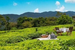
The other major water source in the crater is the Ngoitokitok Spring which is located near the eastern crater wall. There is a picnic site here open to tourists and a huge swamp fed by the spring and the area is inhabited by hippopotamus, elephants, lions and many others.
Many other small springs can be found around the crater’s floor and these are important water supplies for the animals and local Maasai especially during times of drought.
Oldurai or Olduvai Gorge
The Ngorongoro Conservation Area also protects Oldurai or Olduvai Gorges situated in the plains area. It is considered to be the seat of humanity after the discovery of the earliest known specimens of the human genus, Homo habilis as well as early hominidae such as Paranthropus boisei.
The Olduvai Gorge is a steep-sided ravine in the Great Rift Valley which stretches along eastern Africa. Olduvai is in the eastern Serengeti Plains in northern Tanzania and is about 50 kilometers (31 mi) long.
It lies in the rain shadow of the Ngorongoro highlands and is the driest part of the region. The gorge is named after ‘Oldupaai’, the Maasai word for the wild sisal plant.
It is one of the most important prehistoric sites in the world and research there has been instrumental in furthering understanding of early human evolution.
Excavation work there was pioneered by Mary and Louis Leakey in the 1950s and is continued today by their family. Some believe that millions of years ago, the site was that of a large lake the shores of which were covered with successive deposits of volcanic ash.
Around 500,000 years ago seismic activity diverted a nearby stream which began to cut down into the sediments revealing seven main layers in the walls of the gorge.
Wildlife within the Ngorongoro Conservation Area
The Area harbors a large population of wildlife of which approximately 25,000 large animals live in the crater. Large animals in the crater include the black rhinos, Cape buffaloes, hippopotamuses, wildebeests, Grant’s zebras, elands, Grant’s and Thomson’s gazelles and Waterbucks which occur mainly near Lerai Forest.
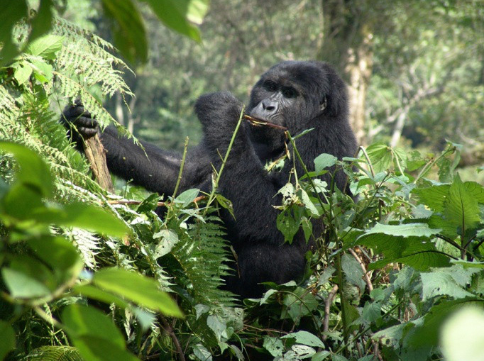
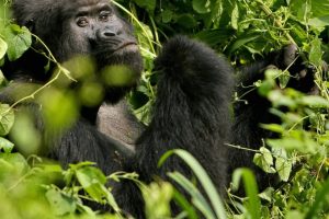
Other wildlife species in the area include; cheetahs, lions, East African wild dogs and African leopards though are rarely seen.
Although thought of as “a natural enclosure” for a very wide variety of wildlife, 20 percent or more of the wildebeest and half the zebra populations vacate the crater in the wet season well as buffaloes and elands do the opposite. Lake Magadi in the southwest of the crater is often inhabited by thousands of mainly lesser flamingoes.
Outside Ngorongoro Crater
The Ngorongoro Conservation Area has a healthy resident population of most species of wildlife. The Ndutu Lake area to in the west of the Ngorongoro Conservation Area has particularly strong cheetah and lion populations.
Common in the Area are hartebeests, spotted hyenas, and jackals. The population of African wild dog in the Area may have declined recently. Servals occur widely on the plains to the west of the Ngorongoro Crater.
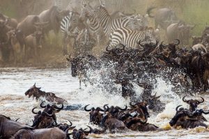
The annual migration wildebeests passes through the Ngorongoro Conservation Area with over 1.5 million wildebeests, 260,000 zebras, and almost half a million of gazelles moving south into the area in December and moving north in June. This movement changes seasonally with the rains but the migration traverses almost the entire plains in forage of food.